
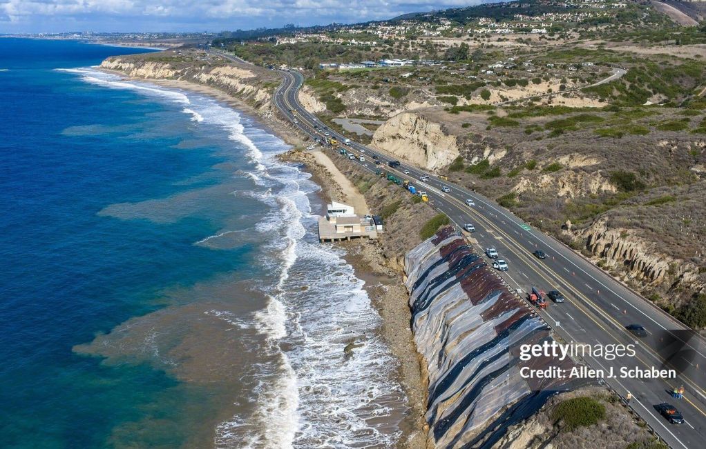

Emergency work near Moro Cove shows why protecting Pacific Coast Highway also involves the shoreline below.
A crack measuring as much as 360 feet along the bluff below Pacific Coast Highway has brought emergency repairs and changes to travel near Crystal Cove State Park. The trouble extends beyond the roadway. California State Parks also closed part of Moro Cove beach below the damaged slope, where repair access and public safety must be managed alongside traffic above.
Caltrans workers discovered the crack near Moro Beach on October 10. A drone survey estimated it reached up to 360 feet in length and 24 inches in width, according to Caltrans statements reported by ABC7 on October 23. An opening of that size raises concern about movement within the supporting bluff. Its visible dimensions help show where the ground has separated; understanding how far the movement may extend requires further information about the slope.
The same bluff affects two public routes
Caltrans first closed the southbound right lane of PCH between Reef Point Drive and Irvine Cove Drive as a precaution. By October 21, reporting described traffic using one northbound lane in each direction while work continued along the ocean-facing slope. That arrangement illustrates the immediate challenge: maintain a route used by commuters and coastal travelers while creating space to stabilize the ground supporting it. Drivers should consult Caltrans for the latest lane configuration.
The beach below has a different access problem. In its October 15 update, California State Parks identified the Moro Cove beach area south of Lifeguard Headquarters as closed until further notice because of the damaged bluff. The agency said it was coordinating with Caltrans, the lead agency for the stabilization project, and facilitating access for assessments and repairs. Other parts of Crystal Cove State Park may remain open even while that specific area is restricted.
The road and the beach serve different purposes, and the two agencies manage different responsibilities. Yet each depends on conditions along the same narrow stretch of coast. Equipment access, protection of people near the slope and changes to the highway can affect how the shoreline is used during the response.
What the crack can tell engineers
A crack near the top of a coastal bluff may be a sign of ground movement. The location, length and width are important observations because they can help engineers identify an area that warrants closer evaluation. Engineers also need to understand the materials beneath the surface, the shape of any moving ground and whether conditions are changing over time. A drone image captures an important part of the problem, while subsurface investigation and continued observations can help explain its extent.
Coastal bluffs are influenced by water from more than one direction. Waves can erode material at the foot of a slope, sometimes reducing the support provided by the ground below. Rainfall and water entering through the surface can affect seepage and groundwater pressure. These processes may act together, and the engineering assessment at Crystal Cove must distinguish general coastal mechanisms from what has actually been found at this particular location.
The distinction matters to the repairs. A buttress adds support near the lower part of a slope. Rock protection at the shoreline primarily absorbs or redirects wave energy and limits erosion. A project may use both functions, and the appropriate combination depends on the observed ground conditions. Understanding the cause and extent of the movement is what allows a longer-term solution to be evaluated.
Protecting the slope while keeping the corridor usable
Caltrans’ October 19 emergency project notice describes temporary slope and roadway stabilization along with measures to reduce wave energy at the bluff’s base. The initial response included covering the crack with protective sheeting to limit water entering from above, according to October 21 reporting. Further work described at the time involved reinforcing the lower slope and adding shoreline rock protection.
This is a difficult place to stage construction. Crews must approach a steep ocean-facing slope beside an operating highway, with tides and surf affecting access to the lower work area. Traffic shifts allow work to proceed on the roadway side, while the beach closure helps protect visitors and provides room to coordinate access from below. The measures are intended to control the immediate condition while engineers and agencies develop the longer-term response.
The longer view of a coastal highway
The emergency repair is also a reminder that PCH crosses a changing coastline. Over time, agencies must consider erosion, storms, drainage, rising water levels and public access when planning how the corridor will function. Those questions reach beyond one crack or one construction season.
Caltrans is separately studying longer-term adaptation along sections of PCH at Crystal Cove and Bolsa Chica. The study considers coastal hazards and possible strategies to keep the route accessible and reliable. It provides a broader planning setting for questions about protecting coastal infrastructure, while the emergency project addresses the damaged bluff now in front of the agencies.
At Crystal Cove, the essential relationship is visible: the road above and the beach below share the consequences of what happens to the bluff between them. A lasting response will need to account for both the transportation route and the public shoreline that makes this stretch of coast distinctive.
Where to find current information
Lane arrangements and beach restrictions may change as repairs proceed. For travel and park access, use Caltrans’ current highway information and the California State Parks Crystal Cove page. The dates in this article describe agency notices and reporting available, rather than a guarantee of present access.
Sources
- California State Parks — October 15, 2026 coastal damage and recovery update
- Caltrans — October 19, 2026 Crystal Cove Coastal Access Preservation Project notice
- ABC7 — October 23, 2026 reporting on the Caltrans discovery and drone measurements
- Daily Pilot / Los Angeles Times — October 21, 2026 construction and roadway report
- Caltrans — Bolsa Chica and Crystal Cove Highway Adaptation Study
- Caltrans — Current highway information
- California State Parks — Crystal Cove conditions
Pacific Skyline provides general infrastructure information based on publicly available sources. This article does not assess the current safety of the roadway or provide project-specific engineering advice.